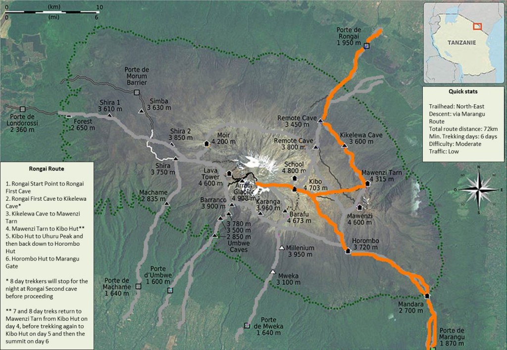
Rongai Route …
Rongai Route – Flatter than other Routes – Remote – starts North on the Kenyan Side – Lasts between 6-8 Days of Hiking – Possibility of Large animcal sightings Mount Kilimanjaro.
The Rongai Route is the only trail that starts from the Northern, or Kenyan side of Mount Kilimanjaro.
Because of its remote location the route offers trekkers a relatively unspoiled wilderness experience where it is possible to see large wildlife like antelope, elephant and buffalo.
The North-East side of the mountain gets significantly less moisture than the southern slopes which means that trekkers are less likely to encounter rain. Trekkers are also more likely to get clear, unclouded views of the mountain.
The Rongai Route is flatter than the other Kilimanjaro routes but because of its profile it does not offer trekkers good options to climb high and sleep low.
It can be hiked on a six, seven or even eight day route. The seven or eight day Rongai Routes are highly recommended as trekkers have extra days to acclimatise.
Summit night from Kibo Hut is steep and follows the same path taken by Marangu trekkers which passes Gilman’s Point to Uhuru Peak.
Due to its remote setting the Rongai Route receives the least traffic of all the routes on Kilimanjaro.
The Rongai Route descends via the Marangu trail.
Rongai Route Map
Day-By-Day Rongai Route Itinerary
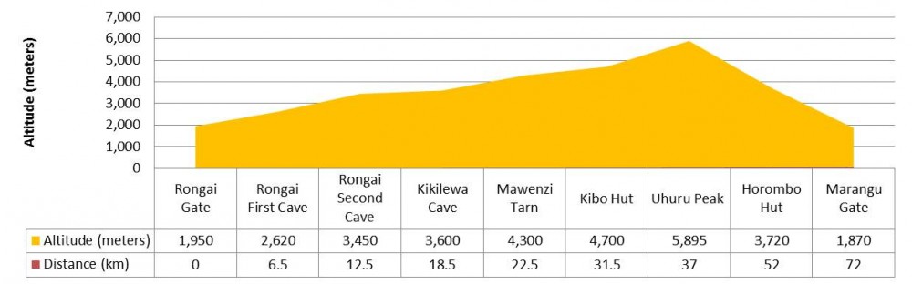
The itinerary below is for a six day Rongai Route trek. Seven and eight day trekkers usually spend an additional day at Mawenzi Tarn (4,300 meters) to acclimatise. Eight day trekkers also stop on day two at Rongai Second Cave (3,450 meters) before proceeding to Kikelewa Camp (3,600 meters).
Day 1 – Rongai Start Point (1,950 meters) to Rongai First Cave (2,620 meters)
Distance: ~6.5km / 3.5 miles
Trekking time: 3-4 hours
Zone: Rainforest
On day one Rongai Route trekkers are driven from either Moshi or Arusha to Marangu Gate for registration before being shuttled a further 70 kilometres on poor roads to the Rongai Start Point at 1,950 meters. The trek begins from Nale Moru village and follows a gradual and winding trail that first crosses maize fields before entering the rainforest. The first day’s hiking is easy going and you will arrive at Rongai First Cave (2,620 meters) around mid-afternoon, where you can freshen up and have dinner.
Day 2 – Rongai Cave (2,620 meters) to Kikelewa Camp (3,600 meters)
Distance: ~12km / 6.5 miles
Trekking time: 6-8 hours
Zone: Rainforest / Low Alpine Zone
On day two the hike continues from Rongai First Cave through the rainforest before transitioning into the low alpine moorland zone where you will notice the vegetation change to shrubs and grasses. You will stop for lunch at Rongai Second Cave (3,450 meters), 6km from the First Cave Camp, before turning east to Kikelewa Camp (3,600 meters) for your overnight stay. Depending on your tour operator, eight day trekkers might stop at Rongai Second Caves for the night before proceeding to Kikelewa Camp.
Day 3 – Kikelewa Camp (3,600 meters) to Mawenzi Tarn (4,300 meters)
Distance: ~4km / 2.5 miles
Trekking time: 3-4 hours
Zone: Low alpine zone / High alpine zone
Day three on the Rongai Route is a short, but steep climb from Kikelewa Camp to Mawenzi Tarn (4,300 meters) which sits in the shadow of the magnificent Mawenzi Peak. You will arrive at Mawenzi Tarn in time for lunch and then have the whole afternoon to explore the surrounding area and acclimatise.
Day 4 – Mawenzi Tarn (4,300 meters) to Kibo Hut (4,700 meters)
Distance: ~9km / 5.5 miles
Trekking time: 8-10 hours
Zone: High alpine zone
Day four is a long but gradual hike from Mawenzi Tarn heading west through the Saddle which is formed between the peaks of Kibo and Mawenzi, and up to Kibo Hut (4,700 meters). The route is dry, barren and rather inhospitable, but provides spectacular views of Kibo. At Kibo Hut you will get served dinner and will go to bed early as you will be awoken around 23:30 to begin your summit attempt. Trekkers should remember to prepare their gear, including headlamp, camera, insulated water and warm weather clothes before they go to sleep.
Note: Seven and Eight day trekkers typically hike from Mawenzi Tarn to Kibo Hut and back on day four. They then trek to Kibo Hut again on day five before continuing to Uhuru peak on day six / seven.
Day 5 – Kibo Hut (4,700 meters) to Uhuru Peak (5,895 meters) and then Horombo Hut (3,720 meters)
Distance: ~5.5km / 3 miles ascent and then 15km / 8 mile descent
Trekking time: 6-8 hours to the summit and then 5-8 hours to Horombo Hut
Zone: Glacial zone, high alpine zone and low alpine zone
Day five begins at midnight, after being awoken with tea and biscuits you will begin your ascent in the dark across a rocky path to the first check point, Hans Meyer Cave at 5,150 meters. You should have a break here and refuel on an energy bar. The path then zigzags and increases in steepness as you approach Gilman’s Point 2-3 hours later at 5,681 meters. You are now on Kibo’s crater rim, a huge achievement! But you still have a 200 meter ascent to trek to the summit, Uhuru Peak (5,895 meters). Dig deep to find the reserves and mental stamina to push yourself up the final slopes. At Uhuru Peak you will be able to stay briefly before descending back to Kibo Hut and on to Horombo Hut. In total you will be trekking upwards of 12-16 hours. It will be one of the longest days of your life but well worth it! Here’s the good news, beers can be bought at Horombo Hut!
Day 6 – Horombo Hut (3,720 meters) to Marangu Gate (1,870 meters)
Distance: ~20km / 13 miles
Trekking time: 6-8 hours
Zone: Low alpine zone and rainforest
The final day from Horombo Hut to Marangu Gate (1,870 meters) is a long one, nearly 20km! Your knees will be sore from the previous days hike so go slowly and make sure of your footing as you descend, using your trekking poles to limit the impact on your joints. At Marangu Gate, the place where you signed in 6 days ago, you will now sign-out. Those who got as far as Gilman’s Point but no further will be presented with a green certificate. Trekkers who made it all the way to Uhuru Peak will receive a gold certificate. Most trekkers present their trekking team with their hard earned tips at this stage before being driven back to your hotel for a well-deserved hot shower!
Rongai Route Altitude and Distance Profile
Packing List
You can access a complete Kilimanjaro gear list here.
Still have questions about the Rongai Route? Please Contact Us.